
Object Record
Images
Metadata
Catalog Number |
2017.020.001 |
Title |
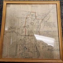
Early map of Barberton |
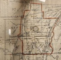
Description |
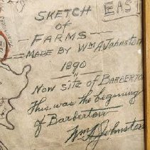
A map drawn in pencil denoting the owners of the farms around Lake Anna. A note in the bottom right corner says the map was made by William A. Johnston. See below for exact text. Johnston was the original platter of Barberton. However, it looks as though the map has been traced from a map or atlas. It is possible that Johnston traced an earlier map he produced. It is also possible someone else traced the map and wrote the note to identify the original creator. The provenance of this item is unknown at this time. In the bottom right corner of the items, it says: "Sketch of Farms made by William A. Johnston. 1890. Now site of Barberton. This was the beginning of Barberton." A signature follows: "Wm. A. Johnston" Above that note, is another note: "Land inside Red lines were the farms of the original Barberton." Followed by signature: "Wm A Johnston" Framed in a light brown wood frame. |
Object Name |
Map |
Accession number |
2017.020 |
People |
Johnston, William A. Wuchter, John Shook, M. Louis Van Hyning, Norman James, D. R. Miller, P. Betz, A. D. Brotsman, WIlliam Hublinger, Mathias Warner, John Cahow, Milo Range, Frederick Baughman, John C. Mong, John T. Gafkey, Fred Hunsberger, Isaac Cackler, Hannah Myres, Susanna Shaw, George A. Deible, C & S Reis, Fred Fisher, John Keller, Samuel Gotwald, H. O. Kepler, Samuel |
Search Terms |
Barberton Ohio and Erie Canal Tuscarawas River Hudson Run Johnson's Corners American Strawboard National Sewer Pipe Company Cleveland Akron and Columbus Railroad Davis Lake |
Subjects |
Maps Farms Farmsteads Farmland Rivers River channels Roads Canals Streams Creeks Land Land use Land Railways |